| Thumbnail | notes |
| So we had this water main break and it made the news. A lot. More than
all the previous Waterworks stories, put together. My job was about
the little mains, called "distribution mains", which are beneath the notice
of the people who run the transmission mains. Think of those as the garden
hoses that take water way across a yard, and my residential-street mains
as basically soaker hoses - just a bunch of tiny leaks from the perspective
of people who run mains that carry a thousand times as much.
I'll be talking about how the system runs at all, on a good day, so you can
understand how crippling it was to lose that one worst-case main, and then
I'll dig into what I was actually somewhat expert in, why the big mains break,
ever. How the system runs, I had to learn for the first time from
Hugh Costello, who planned and designed the big system for his career, and
Alan Beairsto, who managed the staff for the treatment plants, who are
also the operators of that larger system of big mains and the pumps.
|
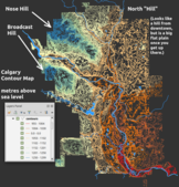
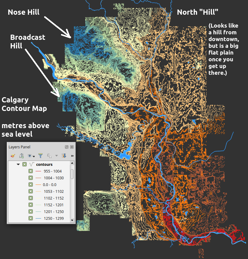
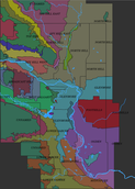
| What is the problem of getting water out to Calgarians? Topography.
So here's the topographic map of the Calgary area, simplified down to
5 metre contour lines.
The map colours the lines by broad bands of elevation, with cool blue and
green colours way up hills, like Nose Hill and Broadcast Hill, and hotter
orange and red colours as you go down the Bow River valley to our lowest
elevations in town, far south.
Our lowest customers are at 950m above sea leavel, our highest, way
up in Spy Hill Jail, are nearly 1250, so that's 300m of elevation difference
across the city. A thousand feet of water pressure, of course, is enough to
blow houses out of the ground, if it were all one continuous pressure vessel, so
it isn't.
| 
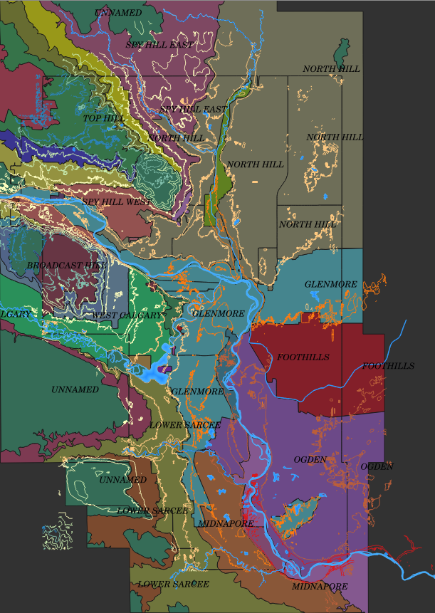
| Instead, the city is broken up into "Pressure Zones", like the globe has
to be broken into time-zones, one hour wide. Pressures are broken out
into bands of pressure, 60 PSI wide. At the top, 40 PSI, and you're
getting a barely strong-enough shower; at the bottom, 100 PSI, and
your hot-water tank is at the max it's rated for.
| 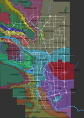
| Here's that map repeated with the major streets superimposed. It isn't
just water systems that are controlled by topography; imagine having
to build Deerfoot Trail anywhere but the low-lying Nose Creek Valley
that developers avoided building in.
You can see that the Glenmore Pressure Zone is the centre of everything;
includes the two big river valleys, the downtown; water radiates out from it
to everywhere else.
That the east side of Calgary, which is flatter, only has a half-dozen zones
from north to south; it's all those hills on the west side that get complicated
to lift water up to.
Calgary is among the luckiest of cities when it comes to good water;
straight out of the mountains, high quality, and we have two separate
rivers, fed by two watersheds; we have a whole backup river, if one
gets contaminated.
| 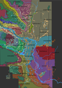
| Let's turn on a few contour lines, by holding them to 25m
intervals. We see that the pressure zones are just contour lines, in their
own right; they have to follow the actual land countours exactly, to the
street.
Notice again that the east side is flat - only a couple of those 25m contours
in the entire Northeast, the "North Hill" zone; the same down south in the
Ogden, Foothills, and Midnapore Zones.
| 
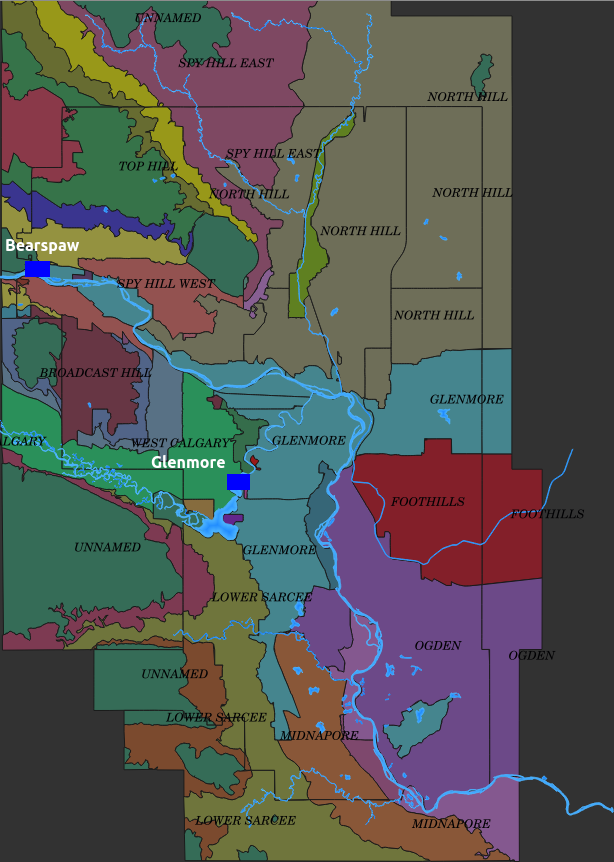
| The problem of serving all this falls on two treatment plants, one
for each river system. Glenmore dates back to 1932, Bearspaw only to
1970.
Some zones are totally dependent on the one plant, get water only from one
river; others get a mix of waters from both, and the mix can change throughout
the day, because of how these plants don't really supply people, exactly:
they supply reservoirs, nothing more than huge concrete boxes we bury
uphill from your house.
| 
| Computer guys would have another name for water reservoirs, which also do
what you have to design into computers and their networks, to handle
the flow of information from one process to another: buffers.
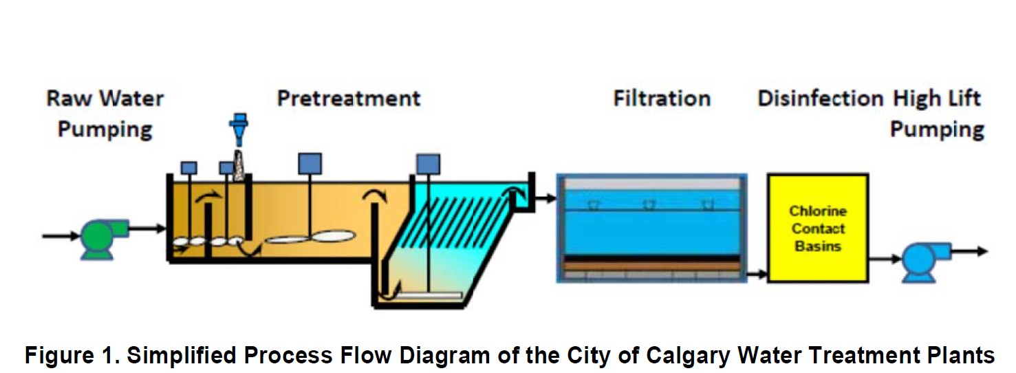
There have to be buffers inside treatment plants, which put water through
several processes that are different machines and tanks. Skipping over
the details of how we treat water, it's multiple processes, in
different buildings, handing water through the assembly line.
None of these processes run at precisely the same number of litres per second, so you have tanks filling up and draining down, between them, until you
get them all in balance. Once you get the whole plant
working at the same number of megalitres per day, you hate to ramp it up
or down. So plants, where possible, run at the same output 7x24 - which demand does not.
| 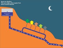
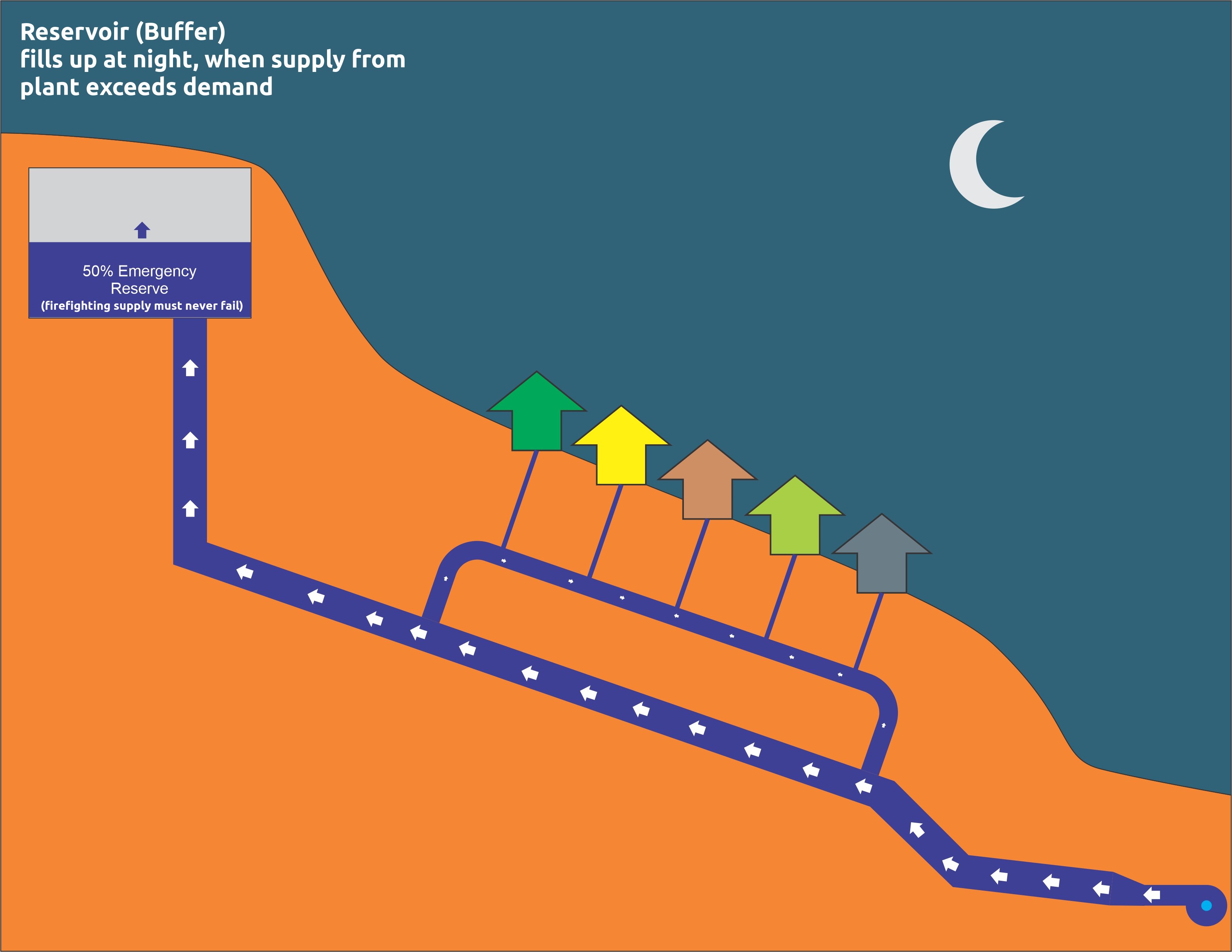
| So the reservoir that serves a pressure zone fills up during the night.
While a little of the water coming uphill from the plant dribbles away into my
little distribution pipes for consumption by night owls, nearly all goes
into the reservoir.
They are never allowed to fall below 50% full, by the way, because we not only
provided drinking water, and garden water, we fight fires. The other
half of that reservoir might be sucked away by a big fire or two, in a matter
of hours, one hydrant putting out as much water per minute as a house uses
in a day. Also, you have a safety level of water, the way aircraft are not
allowed to fly further than 70% of their fuel, divers don't go to the
end of their air, either.
| 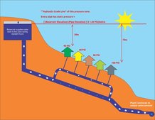
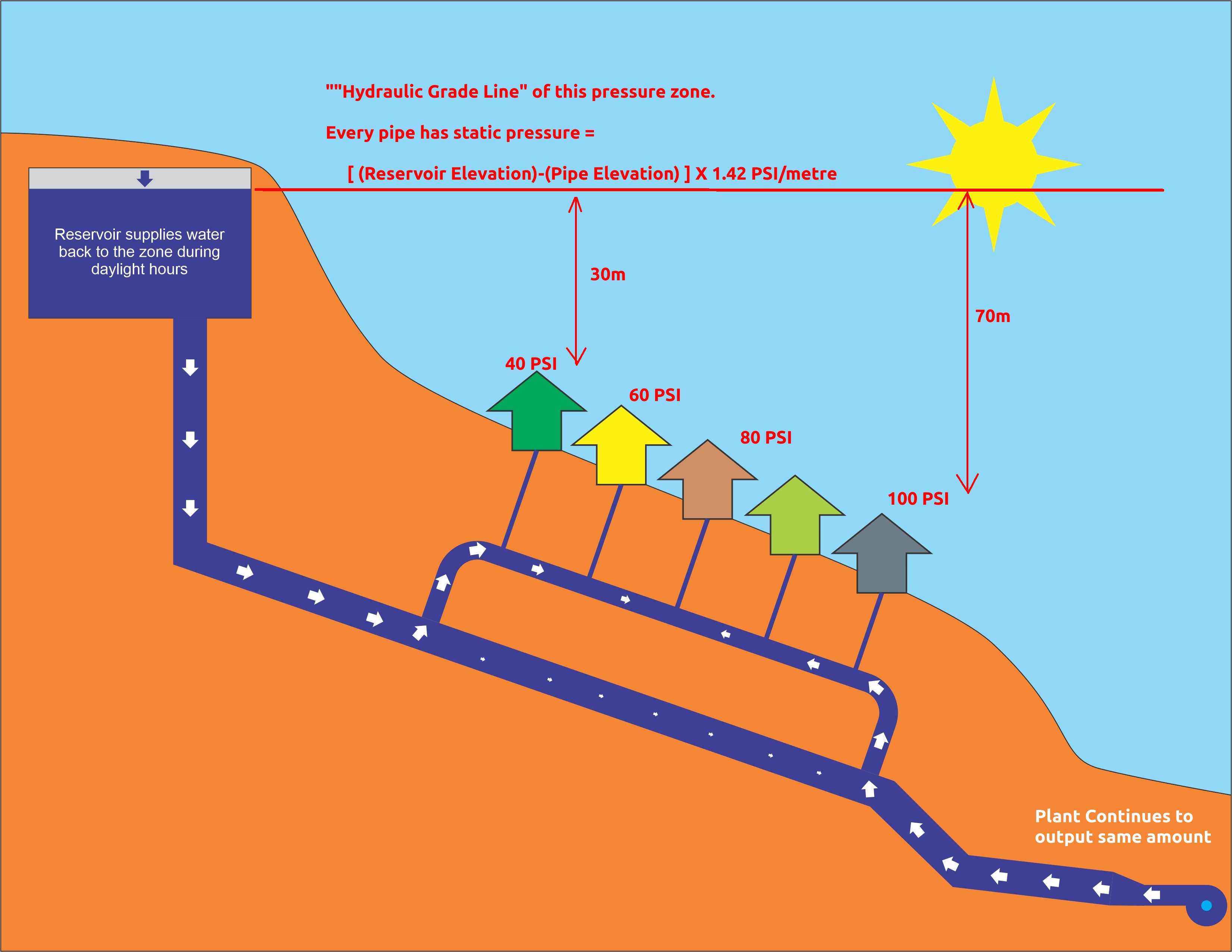
| Then, about dawn, the process turns around. For a minute, the plant output
is just equal to demand; then demand keeps increasing, and all the water
from the plant is going into houses and business, but more has to come back
downhill from the reservoir buffer.
The red lines show the free pressure control and smoothing we get from
reservoirs. All the little on/off jumps in the pumping,
change the pressure on your block by not one iota;
they only affect how much flow gets to the reservoir, not the pressure.
That only changes by a bit, 1.42 PSI per metre, as the reservoir goes up
and down by 2 or 3 metres during the day. Yes, we use the imperial/metric
conversion of PSI-per-metre. We work in metres, but every pressure guage
is made in the USA.
The red horizontal line, we call the "Hydraulic Grade Line" and it's not
quite horizontal, because pressure is lost via flow down any pipe, but
neglecting that, the big deal is how far your house is below your reservoir.
The highest house in a zone has to be nearly 30m below it, for that minimum 40 PSI shower, and can't be more than 70m, to save the hot water tank from cracking.
So, as you'll see, the reservoir that serves a zone is actually sited
inside the zone above it.
| 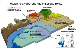
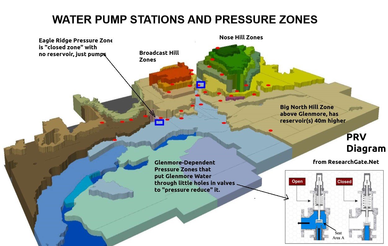
| Reservoir-managed pressure zones, are the classic ones, the ones we prefer,
but there are two others.
This is our coolest pressure zone map, shown in 3D, and all the zones look
like flat shelves, because they show that hydraulic grade line, the top
of the water in the reservoir box. The top of each box is already under
30m of water, so to speak, and as you go down in the box, you're going
further under water. When you open a tap in your house, imagine a submarine
that's 50 metres down, opening a pipe in the hull.
The one long arrow points to a tiny zone just south of the Glenmore Plant, where
the rich folk overlook Heritage Park, and the Moyie in the Glenmore Reservoir.
They don't get a separate zone because they're rich; they get to live on a hill with a view because they're rich, and we had to valve off a separate zone for
that hill - and there was no way to put a reservoir above it.
So little Eagle Ridge is a rare, "closed zone", the pressure created entirely by pumps constantly pushing just enough water to keep the pressure even. When
consumption goes up, more or larger pumps have to kick in; if flow goes
too high, a relief valve opens to let water back out and reduce it.
Then the zones to the east of the Glenmore zone are actually lower than the Glenmore plant. It would be great to just make free power out of that
water going downhill, and you see proposals to scavenge energy from it with
microturbines and so forth. None of them are worth it. So, the plant
just pushes water out into the Glenmore zone, and the lower zones just take
water from it, throw away the extra energy with "Pressure Reducing Valves",
i.e. the water goes through a plate with a small hole in it to turn the
pressure into turbulence and heat, and the valve, like the variable pump, has
a control system to keep the pressure on the downside within limits.
In places, the distribution system has to have closed valves, because across
the street from some 100PSI houses are the houses in the next zone down
at the top of that one, at 40 PSI. One guy opening a closed valve can cause
main breaks and blown-up water tanks across the street. Which has happened,
I'm told. He isn't working here any more.
Notice the "Glenmore Island" - inside the Ogden Pressure Zone, but up
on a hill, so that there's this separate network, valved off from the
rest of Ogden, and connected by a feed pipe over to the main Glenmore Zone,
to give it the Glenmore pressure it needs - on this map, it looks like
a desert mesa.
| 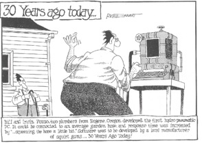
| Here's a parallel between computer and hydraulic networks, if not the
one on this Rich Tennant "Fifth Wave" cartoon, which itself is about 30 years
old today.
The pressure-reducing valves are like firewalls - water goes through only one
way, and the pressure on the other side is protected by assault from uphill.
The pump stations are clearly routers, connected to two networks, the lower
pressure network of pipes on the downside, the higher pressure on the other.
I will, however, be showing you in coming slides that hydraulic network
performance is absolutely not improved by "squeezing the hose a little bit";
quite the contrary, as you'd expect.
| 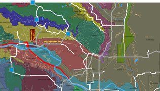
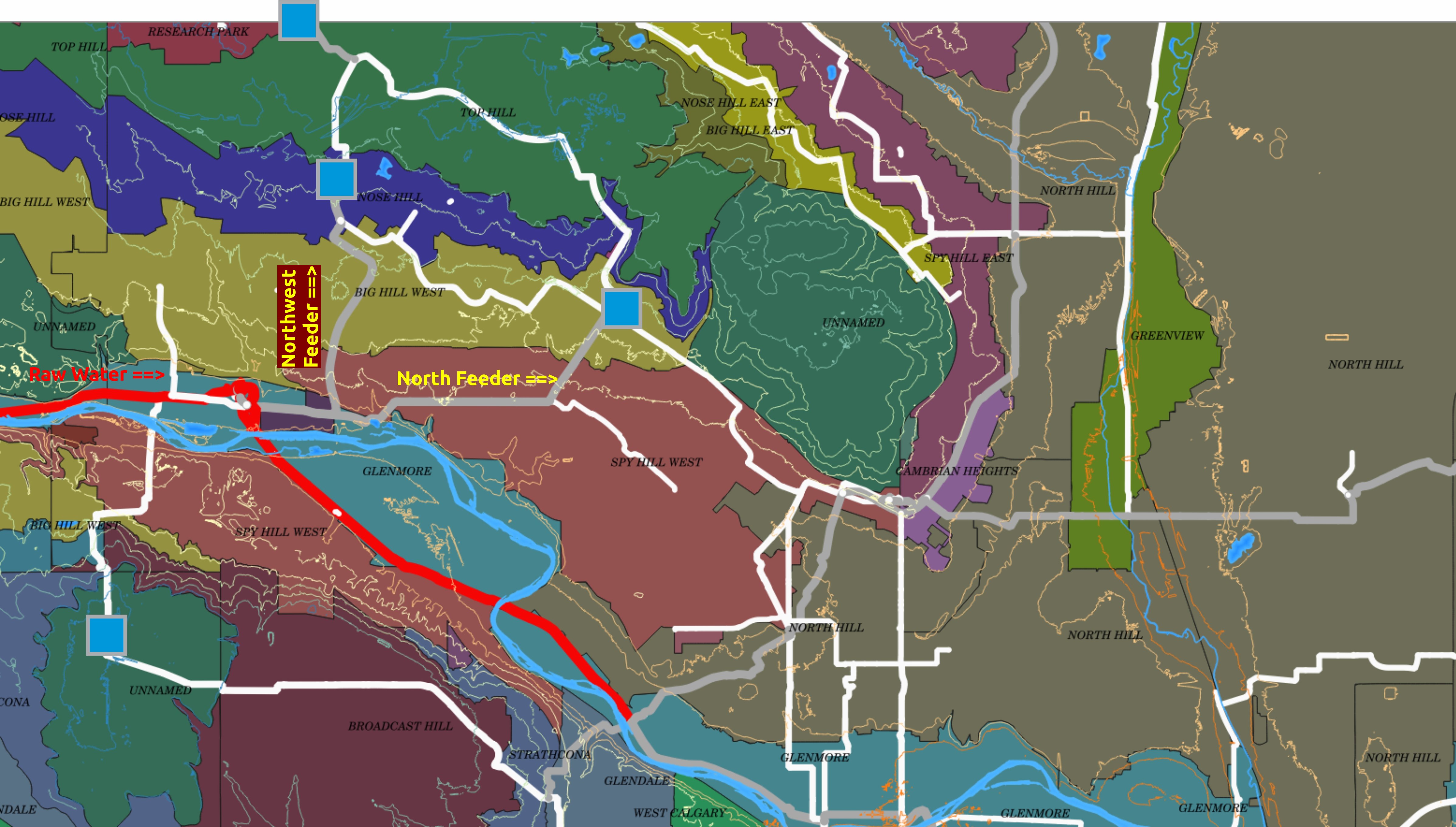
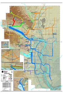
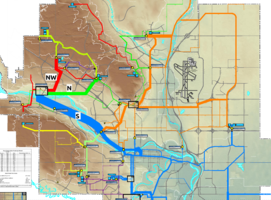
| I thought I could start with the Bearspaw plant, just west of Stoney
Trail bridge. It's right by the river just a ways from a steep hillside
that it has to pump water up, to Spy Hill and Nose Hill.
My own GIS shows the pipe widths proportional to diameter, because I think
about pipe repair and replacement, not operation.
I also set larger pipes to be grey, instead of white, and huge pipes to
be bright red, to call out the Bearspaw South Feedermain that broke. The
red pipe to the west of the plant is the huge raw water pipe
from the Bearspaw Dam that feeds the plant itself.
The two main water-output pipes, besides the giant one, are just called
the North Feeder, straight off to the blue-square, inside the Big Hill
West Pressure Zone, and therefore serving the zone below that, Spy Hill
West. The Northwest Feeder, straight uphill to the Reservoir that's in
Nose Hill Zone, and therefore serves the zone below that, Big Hill West.
| 
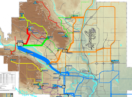
| Hugh had encountered the explanation problem decades back, and worked with
both equations, and with a smart, artistic draftsman to make everything
clear with one simplifying map, shown here.
Hugh ran the calculation for what amount of flow you could get, with a given
amount of pressure, for every large main. The line width isn't quite
proportional to that, because some of the pipes would cover too much of the map
if they did. The draftsman cut down a few, especially the 2-metre Bearspaw
South Feeder, the thickest line in blue, with some artistic license, because
the line's thick enough to make the point.
The flow capacity is not like an electrical resistor, where the current a
cable can carry goes up with cross-section, with the square of diameter. It's
closer to the cube, in the range of diameters we use. The equation actually
has a fifth power on diameter, there are just other complexities that
reduce that to about a cube.
We'll get on to that, but the full-city map shows the huge simplification
Hugh's colour choices provide: rather than dozens of pressure zones, and
pump stations, and detail, there's really just three problems getting
water to Calgary: the blue network is the base, the Glenmore zone, and
all the zones that depend upon it to the east, the ones that are guaranteed
water if you can just keep Glenmore full, they drain from it through
those pressure-reducing valves.
| 
| If we look at the south end of Hugh's flow-capacity map, the just about
everything is blue. Glenmore's main job, by far, is just to push a lot
of water into the Glenmore Zone. That zone fills the whole Bow River valley,
from upstream of Bearspaw, to the far south of town. It can do that, because
the Bow drops less, across the whole city, than the 40-metre elevation band
of one pressure zone. This lets the Glenmore
Zone be the preferred transport route across town. It goes everywhere
but up North, providing water to pump stations that go up
Broadcast Hill, as well as the pressure-reduced zones to the Southeast.
You'd think that meant that all those zones didn't really have to conserve
water during the outage, kilometres up north of Glenmore Plant. You'd be
wrong.
| 
| You see Glenmore's new problem when you look at the North half of the capacity
map, and keep in mind that the draftsman had to narrow the Bearspaw
South Feeder to not have it cover the whole Bow River Valley.
That pipe doesn't take about half the plant output, as it appears; more
like two-thirds, or three-quarters.
The capacity symbology, otherwise, shows how much less important other
mains are. The little red mains off to the west of the plant just serve
small zones on the hills. And, above all, the connections between
Bearspaw-served mains in green and red, off to the east side of
the city, are like paper drinking straws; the red and green networks
just can't provide anything worth mentioning to the orange one.
The big service to the orange pipes, the whole North Hill area and multiple
zones, is about a third of the output from that giant south feeder, grabbed
by the Shaganappi pump station near the Trans-Canada Highway, and pushed
up the North Hill, with a little dodge around McMahon Stadium, up to
Our Lady of Perpetual Pressure.
| 
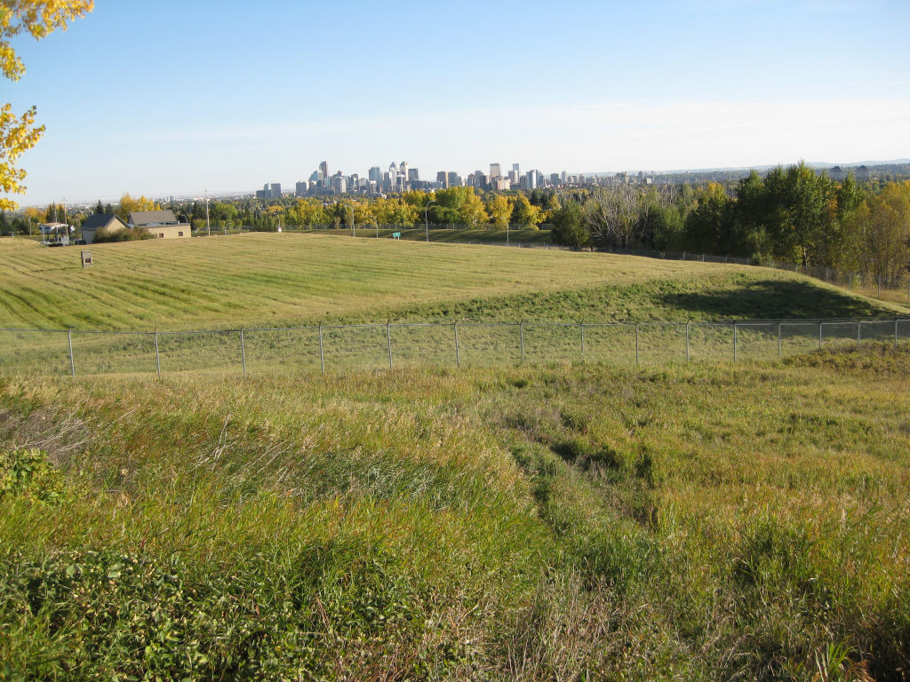
| That's what I've always called the North Hill Pump Station, because it
reminds me of a Church, every time I went by on John Laurie Boulevard
at 14th Street. I think that's the Winter Club parking lot fence
you can see on the right.
The Shaganappi pump station that gets water up to it is arguably even
more important, but North Hill is the Grand Central Station for the whole
north, moving water uphill, sideways between zones of equal pressure, and
even sometimes downhill, into far-eastern zones that need extra pressure
because of distance.
Then the orange network goes through various zones, but all of them depend
on water getting pumped up here, to Our Lady of Perpetual Pressure.
A certain amount can be pumped up from Glenmore
out east, but most has to come up this pipe at Shaganappi. Get it to
our here, and the whole North and Northeast is covered.
And then there are a few brightly-coloured, complicated zones we just
looked at, right above the Bearspaw Plant. They aren't that much of
the city; the Blue and Orange networks are a good 75% of the whole
city.
| 
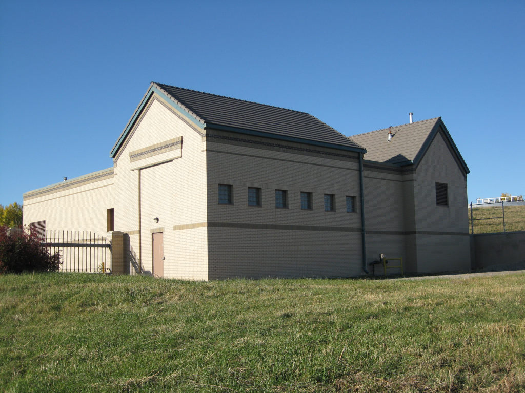
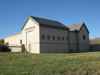
| It has its own reservoir, which has to be the most-easy to see in the
whole city, seen here from Nose Hill Park just above it, looking like
a cardboard box that somebody threw a sheet over. This is the
Rome, that all hydraulic roads in the North lead to, and from.
| 
| So consider the problem of getting water to that Rome, and on to the
North East quarter of the city, and a quarter of our population: to the
airport, so it can stay open...with the big South Feeder, with the S
on it, shut down.
There's just paper straws from the green and red pipes to the west;
just paper straws connecting the east side of Glenmore up the hill.
Normally, a fair fraction of Bearspaw's flow keeps going east from
Shaganappi; Bearspaw water feeds downtown, goes into the "crosstown" main
through downtown to points east; helps flow southward into Glenmore.
All that, the Glenmore plant had to serve on its own; and, much more,
it had to send flow to all the pump stations supplying the North Hill,
and they may have had to run water backwards up to Shagannappi, to
supply water to this lime green main that goes under the river and
up Broadcast Hill.
That, in one slide, is why nearly everybody in Calgary had to conserve
water. The southern plant had to deprive its normal customers to serve
the northeast, because Bearspaw just had no links over there, except
that one, very critical, main.
We'll get back to how Calgary system planners backed themselves, and
everybody, into that corner, where there was a single point of near-complete
failure. But now I'll start my story, of how that failure slipped past
all my plans to prevent it.
|